Now Metro and LCDC are coming up with even more restrictive and regulatory schemes aimed at protecting open space. Yet those schemes are unfair, imposing huge costs on a few for the benefit of many.
Oregon is not suffering from a shortage of open space. Yet Metro wants to destroy thousands of acres of open space nearby people's homes with the dubious goal of protecting other open space that most people will never see.
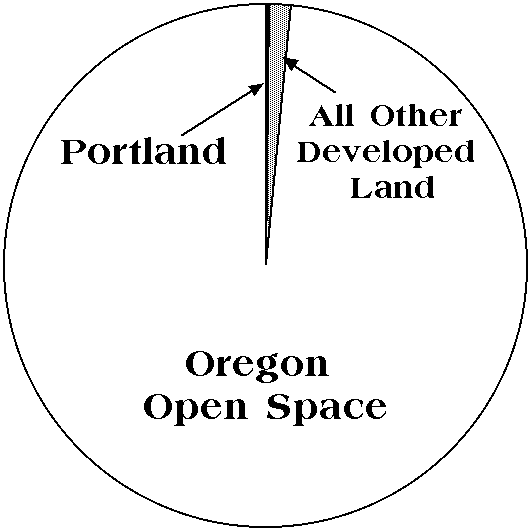
Figure one: All developed land in Oregon, including urban areas and rural roads and railroads, totals just 1.8 percent of the state. Portland alone is just a third of a percent. Source: Natural Resources Conservation Service.
In fact, more than 98 percent of Oregon is open space. According to Metro, only 150,000 acres inside the Portland urban-growth boundary had been developed land by 1995. This is less than a quarter of a percent of the state. Throughout the state, urban and rural developments take up just 1.8 percent of Oregon. Even if Portland and all other urban areas double in size, Oregon will still be 97 percent open space.
Nor are farmlands at risk. Oregon has more than 17 million acres of farmlands, which is more than twenty times as many acres as are in urban areas. In the Portland tri-county area alone, there are around twice as many farm acres as urbanized acres. But only one out of six acres in the tri-counties are farmed, so urban areas have plenty of places to grow without reducing farms.
This doesn't mean that there are no areas of open space that deserve protection. The problem is how to decide which areas to protect and how to protect them without imposing all the costs on a few people.
The U.S. Natural Resources Conservation Service inventories farm, forest, and urban and other developed acres every five years. We can compare this inventory data for 1982 and 1992 to see how well Oregon's land-use laws are working.
Like many other western and southern states, Oregon's population grew rapidly between 1982 and 1992 as people moved here from eastern and midwestern states. As people moved to Oregon urban areas, they naturally took up more space. If "sprawl" consists of a wasteful expansion of urban areas, then we can measure sprawl by comparing the growth of developed land with the growth of the population.
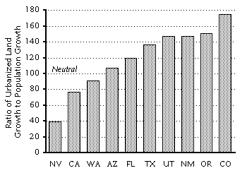
Figure two: The ratio of he growth of developed land to the growth of a state's population between 1982 and 1992 is a good indicator of sprawl. When the ratio is more than 100, the state's urban areas are "sprawling." Other than Florida, none of the states shown had Oregon's restrictive land-use laws, yet Oregon's urban areas sprawled faster than any state except Colorado. Source: Natural Resources Conservation Service (developed land), Census Bureau (population).
Figure two shows that, of the major fast-growing states of the West and South,
Oregon sprawled faster than every state except Colorado between 1982 and 1992.
Urban areas in Nevada, California, and Washington actually got denser, which is
supposed to be the goal of Oregon planners. But Oregon, for all its land-use
regulation, saw developed land grow more than 50 percent faster than its
population.
One indication of the failure of LCDC's planning is that LCDC has passed a succession of increasingly restrictive rules as each previous rule fails.
Regulation always produces unintended consequences: The consequence of a rule requiring that a farm produce a minimum income before a home can be built is that the best land will be subdivided first. Too often, the costs of the unintended consequences are greater than the benefits of the rule--so great that the rule sometimes fails to even accomplish its goal.
Even so, the boundary was unfair to many landowners: Today, the value of an acre inside the boundary might be $10,000 or more, while the value of an otherwise identical acre right outside the boundary might be just a few hundred dollars.
Despite this unfairness, some people soon saw the boundary as a near-sacred line, not to be moved under any circumstances. A group of leading planning advocates formed the "Zero-Option Committee" to lobby against expansion.
Eventually, however, the boundary will get filled up. Rapidly rising land prices in recent years suggest that Portland is near that point. Instead of expanding the boundary, zero-option advocates pushed for higher density development. Metro has therefore given population targets to every city and county in the area, and those cities and counties are supposed to rezone to meet those targets.
This means smaller lot sizes, more rowhouses, apartment buildings, and other higher-density developments. Some people want to live in such areas, but many do not. To promote such developments, Metro, Portland, and other cities are allowing tax breaks, waiving development fees, and giving direct federal grants to developers of high-density residential areas.
Metro's higher density prescriptions have their own unintended consequences.
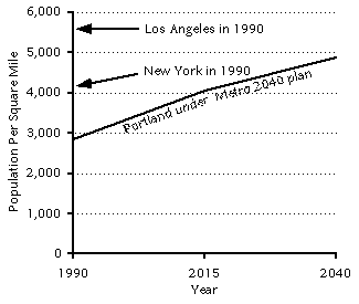
Figure three: Under Metro's 2040 plan, Portland's population density will surpass the 1990 density of the New York urban area (which includes northern New Jersey) by 2015 and will be nearly 5,000 people per square mile by 2040.
The ultimate unintended consequence is that the congestion, housing prices, and
high consumer goods prices will make Portland such an undesirable place to live
that fewer people will want to live in the city, taking refuge by building
their homes on open space outside of the urban-growth boundary. Metro's plan
may therefore lead to even faster subdivision of farmlands than would otherwise
take place.
The real irony is that Metro wants to develop 13,000 acres of prime farmlands within the urban-growth boundary. Many Portlanders enjoy convenient u-pick berries and other produce from these lands, and the farmers would rather farm than subdivide. But Metro considers these farms an obstacle to its plans for a high-density city and has targeted them for development.
One such incentive is the exclusive farm-use zone, which taxes farmers less provided they don't develop their land. Another might be to create an open-space trust fund that can buy conservation easements from high-priority open space surrounding the Portland area. Steps such as these will protect Oregon's livability without the inequities and unintended consequences of Metro's plans.
Metro, Buildable Lands Analysis, March 1996, p. 2 (number of developed acres in Portland growth boundary).
Natural Resources Conservation Service, Natural Resources Inventory, 1995 (growth of developed land in figure one, acres of farm and developed land).
U.S. Census Bureau, Statistical Abstract of the United States (1982 and 1992 state populations for figure one).
This fact sheet was prepared by the Thoreau Institute for ORTEM, a citizens' group opposed to the Metro 2040 plan. Fact sheets are available on a variety of other topics, including congestion, growth, and light rail. If you have any questions or would like hard copies of this fact sheet, please call or write the Thoreau Institute, 14417 S.E. Laurie, Oak Grove, Oregon 97267, 503-652-7049, or email rot@ti.org.